Sioux Falls and Other Cities Break Cold Temp Records
Sam Gabrielli from KSFY TV pointed out just how cold it was around the Sioux Falls area on Sunday. Several locations broke record low temperatures Sunday morning.
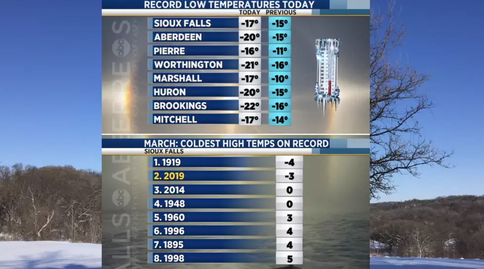
Sioux Falls set some new March records. A new RECORD LOW TEMPERATURE of -17 and the 2ND COLDEST HIGH TEMPERATURE of -3 was set yesterday. The previous record low for Sioux Falls was -15.
Here are some other low-temperature records were set around the area:
- Aberdeen - -20
- Pierre - -16
- Worthington - -21
- Marshall - -17
- Huron - -20
- Brookings - -22
- Mitchell - -17
And just to rub it in a little bit, we have more cold March weather in the forecast from the National Weather Service in Sioux Falls.
Monday: Patchy blowing snow after noon. Mostly sunny, with a high near 7. Wind chill values as low as -29. Blustery, with a west northwest wind 15 to 20 mph, with gusts as high as 30 mph.
Monday Night: A chance of flurries with a slight chance of snow before midnight, then a chance of flurries between midnight and 3:00 AM. Mostly cloudy, with a low around 0. West northwest wind around 15 mph, with gusts as high as 25 mph. Chance of precipitation is 20%.
Tuesday: A chance of flurries after 3:00 PM. Mostly sunny, with a high near 13. Wind chill values as low as -18. West northwest wind 10 to 15 mph.
Tuesday Night: Mostly clear, with a low around 0. West wind 5 to 10 mph.
Wednesday: Mostly sunny, with a high near 17.
Thursday: A chance of snow. Mostly cloudy, with a high near 17. Chance of precipitation is 40%.
Friday: Partly sunny, with a high near 27.
More From Hot 104.7 - KKLS-FM