Severe Weather For South Dakota, Minnesota, & Iowa In December?!
If you're feeling like we skipped winter and moved right to spring weather all of a sudden, you're not alone.
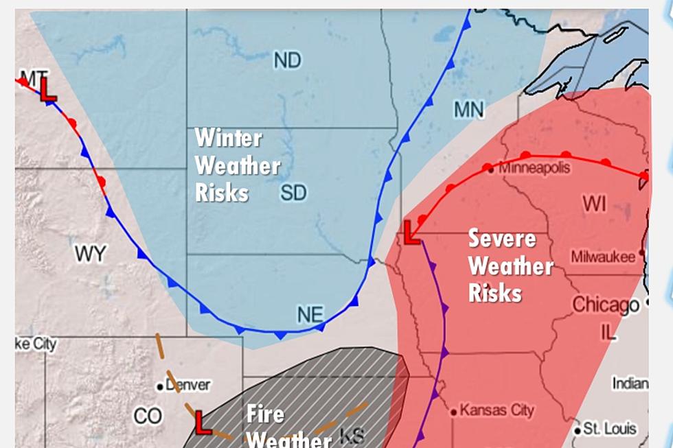
The National Weather Service in Sioux Falls and our news partners at Dakota News Now are both reporting that a strong storm system will approach parts of South Dakota, Minnesota, and Iowa on Wednesday, December 15th. This is not your typical "December snowstorm." The biggest threats in this "dynamic" and fast-moving storm system are strong winds, large-sized hail, and some possible tornadoes.

According to the National Weather Service, Wednesday's weather is "a rare and potentially historic severe weather event that will unfold for the region today and tonight." These thunderstorms and other weather threats will start "to form over eastern Nebraska." Beginning Wednesday afternoon around 3 PM, the region will start to see the storm system move in. You can expect thunderstorms, high winds, and maybe tornadoes. However, greater chances for tornadoes will be in Iowa and Minnesota.
If the temperatures begin to drop, snow is not out of the question either! The National Weather Service states, "There remains some uncertainty on where snow may form due to the intense nature of this system, but signs point to the potential for upwards of 2-3 inches of snow by midnight Thursday. Also, crashing temperatures will lead to flash freeze potential in many areas."
Dakota News Now explains that a majority of the area has already posted High Wind Warnings and Winter Weather Advisories. The Sioux Falls area already has a Dense Fog Advisory that expires around 9 AM. It looks like pea soup out there!
Dakota News Now says severe weather will be possible in northwestern Iowa "where some storms could produce wind gusts up to 70 mph and quarter-sized hail." It will even be warm enough where thunderstorms occur in northwest Iowa. Once the cold front moves in, snow showers can happen with the possibility of accumulating 1-3 inches of snow.
When it comes to the weather in Sioux Falls, the city may experience a couple of storms that can produce wind gusts of up to 65 mph.
There is just a ton of weather happening. When I spoke to Dakota News Now Meteorologist Tyler Roney, he told me that the National Weather Service in Sioux Falls has never issued a Severe Thunderstorm or Tornado Warning in the month of December dating back to 1986 when records for these types of events started being documented.
You never know what weather will be like in the Midwest. It's just a smörgåsbord.
TRENDING FROM RESULTS-TOWNSQUARE SIOUX FALLS:
- South Dakota Sandwich Makes List of 99 Best in America
- You Must-See These Christmas Lights In Sioux Falls
- Top 10: Check Out the Most Common Last Names in South Dakota
- Sioux Falls Area Teachers Scramble For Cash Called 'Degrading'
The Coldest Temperatures in Sioux Falls History
Do You Remember These 10 Crazy Snowstorms In South Dakota?
More From Hot 104.7 - KKLS-FM